


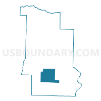
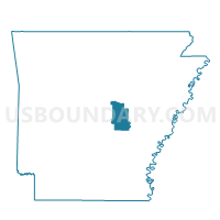
PETTUS Voting District, Lonoke County, Arkansas
About
Outline

Summary
| Unique Area Identifier | 527209 |
| Name | PETTUS Voting District |
| County | Lonoke County |
| State | Arkansas |
| Area (square miles) | 37.35 |
| Land Area (square miles) | 36.90 |
| Water Area (square miles) | 0.45 |
| % of Land Area | 98.81 |
| % of Water Area | 1.19 |
| Latitude of the Internal Point | 34.60220990 |
| Longtitude of the Internal Point | -91.89776020 |
Maps

Graphs
Select a template below for downloading or customizing gragh for PETTUS Voting District, Lonoke County, Arkansas


Neighbors
Neighoring Voting District (by Name) Neighboring Voting District on the Map
- CROOKED CREEK Voting District, Lonoke County, AR
- FLETCHER Voting District, Lonoke County, AR
- GUM WOODS Voting District, Lonoke County, AR
- INDIAN BAYOU Voting District, Lonoke County, AR
- LAFAYETTE Voting District, Lonoke County, AR
- RICHWOODS Voting District, Lonoke County, AR
- SCOTT Voting District, Lonoke County, AR
- WALLS Voting District, Lonoke County, AR
Top 10 Neighboring County Subdivision (by Population) Neighboring County Subdivision on the Map
- Gum Woods township, Lonoke County, AR (2,997)
- Crooked Creek township, Lonoke County, AR (693)
- Lafayette township, Lonoke County, AR (308)
- Indian Bayou township, Lonoke County, AR (304)
- Fletcher township, Lonoke County, AR (200)
- Richwoods township, Lonoke County, AR (193)
- Pettus township, Lonoke County, AR (168)
- Walls township, Lonoke County, AR (111)
- Scott township, Lonoke County, AR (92)
Top 10 Neighboring Unified School District (by Population) Neighboring Unified School District on the Map
- Lonoke School District, AR (9,959)
- Carlisle School District, AR (4,202)
- England School District, AR (4,198)
Top 10 Neighboring State Legislative District Lower Chamber (by Population) Neighboring State Legislative District Lower Chamber on the Map
Top 10 Neighboring State Legislative District Upper Chamber (by Population) Neighboring State Legislative District Upper Chamber on the Map
Top 10 Neighboring 111th Congressional District (by Population) Neighboring 111th Congressional District on the Map
Top 10 Neighboring Census Tract (by Population) Neighboring Census Tract on the Map
- Census Tract 207, Lonoke County, AR (2,989)
- Census Tract 206, Lonoke County, AR (1,815)
- Census Tract 208, Lonoke County, AR (1,318)